Striking rock formations inspire tall tales of their origins, but geology tells the story of science and the state’s deep history.
This story was originally published in the October 2022 issue of Wonderful West Virginia.
To subscribe, visit wonderfulwv.com
Written by Wendy Holdren
Photography courtesy of WV Tourism Department
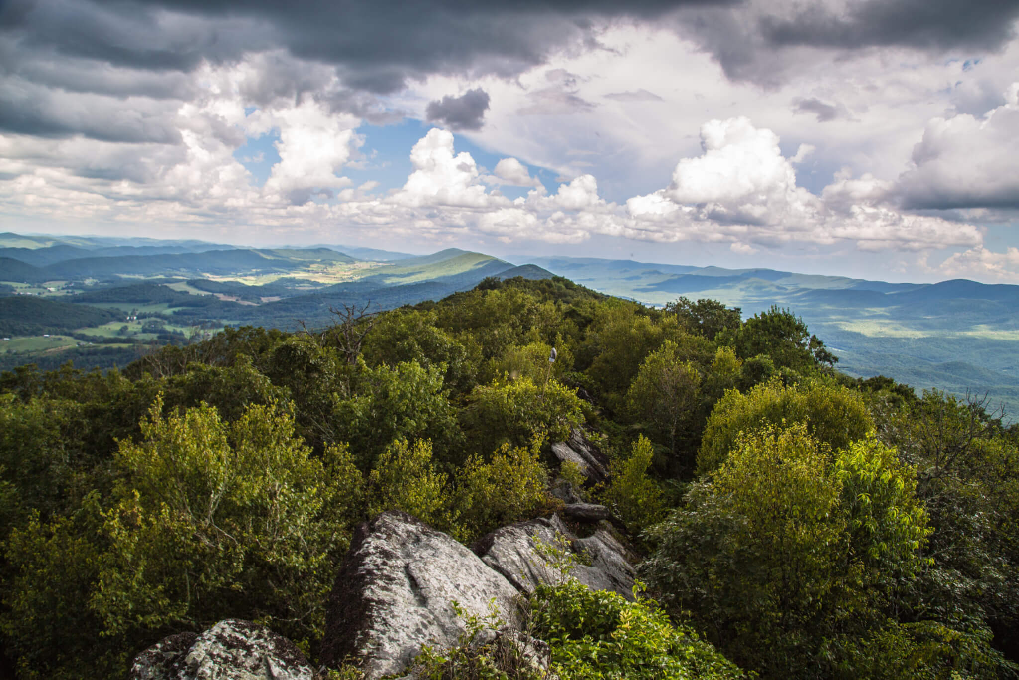
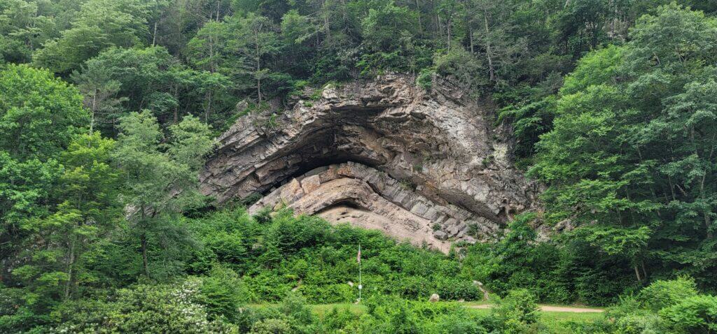
Roughly seven miles southeast of Marlinton and less than a mile southeast of Huntersville, an eye-catching geological formation known as The Devil’s Backbone is sure to slow motorists traveling along Knapp Creek on West Virginia Route 39.
“People are intensely interested in rocks,” says David Sibray, editor-in-chief of West Virginia Explorer. “There’s something about large rock formations that attract attention and inspire intense interest, and especially this rock formation. It’s so unique—it’s something that piques the imagination.”
Sibray, who writes about a variety of subjects in the Mountain State, says many seemingly unexplainable phenomena in West Virginia have become attributed to the occult. There are even additional “devil’s backbones” in the state, including an arch-like formation in Raleigh County near the source of the Guyandotte River. “Over time, people have come to attribute it to a supernatural work, or even the work of the devil.”
The real origin of the Pocahontas County rock formation, while much less sinister, is no less interesting.
The Sands of Time
The Devil’s Backbone is an anticline, a fold in rock that resembles an arch, formed by compression, or “squishing,” according to West Virginia University geology professor Joe Lebold. It’s part of a much larger geologic structure called the Brown’s Mountain Anticlinorium, which has the basic arch shape, but it is not continuous in the middle; rather, it is broken by faults and has secondary folds.
“When you look at Brown’s Mountain, the Devil’s Backbone is a tiny little fold, but it’s representative of the stress that formed the whole thing,” Lebold says. “It’s hard Silurian sandstone, the same as Seneca Rocks. Even with millions of years of rain and snow, it still sticks out because it’s so hard. It gives us a glimpse of the rocks that underlie the landscape.”
Lebold explains that when the supercontinent Pangaea formed about 250 million years ago, continents collided. “When you squish rock, it doesn’t snap back. At some later point, you get a record of that compression, and a lasting one.” In terms of size, Lebold says the Devil’s Backbone is a few tens of meters tall. “It looks big, but it’s really just a small bump on the Brown’s Mountain Anticlinorium, which is a major structure roughly five miles across, all formed from the same event.”
Dating even further back, roughly 440 million years ago, the rock itself is formed from Tuscarora sandstone, Lebold explains, which comes from a shallow marine deposit of sand that likely accumulated in less than 30 meters of water. “It was saltwater, like a beach and barrier island environment during the Silurian period. The sand that makes up the sandstone—that was in an ocean. At that time, the loose sand would have been shaped by tides and waves, like it is along the coasts today.”
For the next roughly 200 million years, Lebold says, seas came and went. As evidenced in many other layers with ancient seashells, today we can see which ones were deposited below and above sea level. The younger sediments would have buried the Silurian sand several miles below the surface, where it would be transformed to sandstone.
Over geologic time, as the sea levels rise and fall, beaches shift. “We think of a beach as a place, but as it moves, it spreads the sand over time,” Lebold explains. “That’s how the Tuscarora sandstone can extend from southern New York down to West Virginia and across to Tennessee. If you think about the modern Atlantic coast, the beaches run up and down—when the sea level rises, it comes in, and when it falls, it moves out into the basin.”
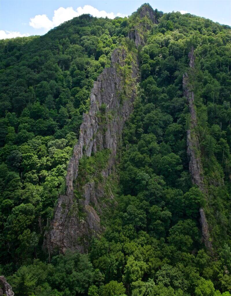
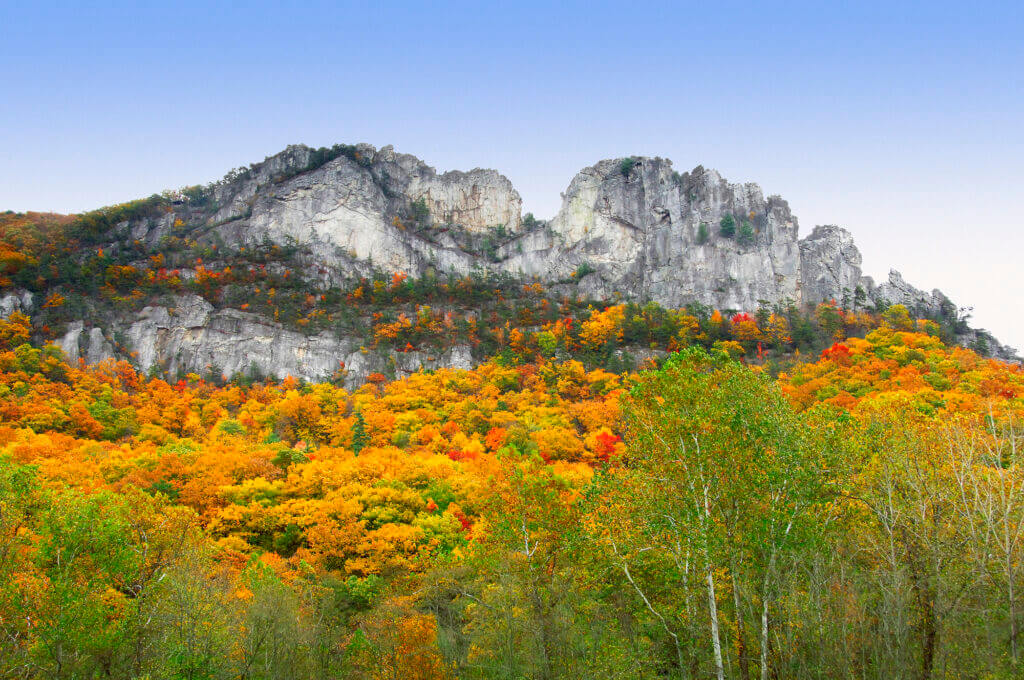
Champe Rocks, Nelson Rocks, and Seneca Rocks are all formed from the Tuscarora sandstone as well. These outcrops are part of a different anticline where one limb of the fold is very steep, with the rocks now in a vertical position, Lebold says. This is likely due to the limb being dragged along a fault, tugging and rotating the layers.
“We don’t want people to drive all over West Virginia and think it’s all the same,” Lebold says. “There are very different forces at work, and the way the geology manifests itself is very different from place to place. Our goal is to show people those differences.”
Telling the Stories of the Mountains
“For me, the most fascinating thing is thinking of all the different things West Virginia used to be—a sea, a coastline, coastal coal swamps, and, since Pangaea, essentially dry land being eroded. It’s so different today from what it used to be. There’s a series of stories the rocks tell.”
Lebold has always loved geology and feels fortunate that he could make a career out of it. He was first exposed to geology class in college and found it fascinating to understand the foundational science behind the Earth science classes he’d taken as part of his K–12 education. After receiving his undergraduate degree, Lebold obtained his master’s and then his Ph.D. in geology.
Inspired by Mountain Press Publishing Company’s national Roadside Geology series, Lebold hoped to one day add something to the collection. During his Geology of West Virginia course, he met a retired WVU music professor, Christopher Wilkinson, who audited his course out of personal interest. Wilkinson grew especially interested and, when he learned of Lebold’s interest in writing a book, he suggested they pursue the effort together.
The two balanced each other well, Lebold’s training in geology complementing Wilkinson’s passion for the state’s landscapes. As a published author himself, Wilkinson knew the ropes and helped contact a publisher. Together, they turned in a draft chapter to see if it would be a good fit, and so Roadside Geology of West Virginia was born.
The endeavor took a total of four years, with Lebold scrounging time between teaching full-time, usually between late fall and early spring, as the bare trees offered the best views of the rocks. They would map out their route to circumnavigate the state in the most efficient way possible, with Wilkinson driving and Lebold referencing his notes.
“Seeing how the geology is expressed in West Virginia—there’s so much cover, so many trees, so many soils. If you tell someone about a type of rock, they may see it or not, but they’ll see how it’s expressed in the hills. It’s something they can see and touch in the landscape. We definitely had to incorporate that, communicating those stories.”
Wilkinson served as an excellent sounding board, helping Lebold understand what was difficult to visualize or conceptualize. The feedback helped him contextualize the relative ages of rock formations and sequence of events. Admittedly, Lebold says even he as a geologist still finds the numbers astonishing. Together, he and Wilkinson set out to write a book accessible to the general public, not just a scientific audience.
Their 297-page Roadside Geology of West Virginia was published in 2018 by Mountain Press Publishing. The book can be found online and is sold in the state at Pathfinder sporting goods store in Morgantown.
See It for Yourself
Sibray encourages anyone who hasn’t seen the striking Devil’s Backbone rock formation to take a road trip to Pocahontas County. Individual travelers, friends, or families can easily make a full day of their trip with other area attractions, such as Snowshoe Mountain Resort, the Marlinton Opera House, the Highland Scenic Highway, the Allegheny Trail, or Cranberry Glades Botanical Area.
“The average West Virginian knows the mountains are unique and old, but the unfolding of that story is always new and surprising,” Sibray says. “Also, I’ve never taken a picture of the Devil’s Backbone in which the scale translates. You have to see it in person to appreciate its magnitude. It’s truly striking.”
You’ll find the geological formation located along Knapp Creek at WV 39 just south of Huntersville—or, to name some bigger landmarks, it’s 35 miles south of Snowshoe Mountain and 50 miles north of Interstate 64 at Lewisburg.